| Marker Name | Location | Marker Text |
|---|---|---|
| A BATTERY OF GUNS PLACED ON | On The Portage At Ticonderoga | Mount Defiance By British Artillery Officers In July 1777 Forced Evacuation Of Fort Ticonderoga By General St. Clair. |
| ALONG THIS STREET RAN THE… | On The Portage At Ticonderoga | New York Old Military Road Fortified In 1759 By General Amherst Prior To His Siege Of Fort Ticonderoga |
| ARROW… | On Mt. Hope Ave. At Ticonderoga Ticonderoga | On Hill Above Mount Hope Battery Occupied By General Burgoyne 1777 |
| COLONIAL AND REVOLUTIONARY… | On NYS Rte. 8 & NYS Rte. 22 About 3 Miles N. Of Ticonderoga | New York Military Road Crown Point To Ticonderoga |
| COLONIAL AND REVOLUTIONARY… | On NYS Rte. 8 & NYS Rte. 9N & NYS Rte. 22 About 3½ Miles N. Of Ticonderoga | New York Military Road Crown Point To Ticonderoga |
| FATHER JOGUES.. | On Black Pt. Rd. So. Of Ticonderoga | Rene Goupil And Guillaume Coutre In 1642 Were The First White Men To See These Waters Named Lac Du St. Sacrement By Jogues In 1646 |
| GARRISON CEMETERY… | On Ft. Ticonderoga Reservation At Ticonderoga | Here Are Buried Several Hundred Officers And Men Of The American Army Chiefly New York New Jersey And Pennsylvania Militia 1775–1777 |
| HERE STOOD… | On Ft. Ticonderoga Reservation At Ticonderoga | The King’s Store A Stone Building Erected By The French In 1756 And In Use For About 100 Years. |
| HUT SITES… | On Ft. Ticonderoga Reservation At Ticonderoga | Within A Radius Of |
| NEAR HERE MARCH 13 1758… | On Ticonderoga Country Golf Course So. Of Ticonderoga | New York Rogers’ Rangers Fought The Snowshoe Battle And Were Defeated By French And Indians Under Durantaye And Langy |
| NEAR HERE ON JULY 30 1609… | On Ft. Ticonderoga Reservation At Ticonderoga | Samuel De Champlain Aided By Two Frenchmen And Huron And Montagnais Allies Defeated A Band Of Iroquois Warriors |
| NEAR HERE ON JULY 6 1758… | On Alexandria Ave. Southwest Of Ticonderoga | Lord Howe was killed In A Skirmish With A French Advance Guard Under Langy And Trepezec |
| NEAR THIS SPOT STOOD THE… | On Alexandria Ave. At Ticonderoga | House And Store Of John Stoughton First English Patentee At Ticonderoga 1764 |
| ON THE EAST SHORE OPPOSITE… | On Black Pt. Rd. So. Of Ticonderoga | This Place Were Erected Two Blockhouses To Guard The Narrows And Landing Place 1759. |
| ON THIS POINT IN 1759 STOOD… | On Black Point Rd. South Of Ticonderoga | Blockhouse The Southerly Outpost Of The Fort. Here Landed Rogers Rangers As The Vanguard Of General Amherst’s Army. |
| ON THIS SPOT IN 1756… | On Black Point At Ticonderoga | New York French Engineers Built A Redoubt To Guard The Bridge And Landing Place At The Head Of The Portage. |
| OPPOSITE THIS SPOT ON THE… | On Baldwin Rd. So. Of Ticonderoga | West Bank Of The Outlet Of Lake George Stood A Blockhouse And French Defenses To Cover The Bridge And Landing Place. |
| REDOUBT… | On Ft. Ticonderoga Reservation At Ticonderoga | Lotbiniere Built By The French In 1756 Called By The British And American Armies The Grenadiers’ Battery |
| SCENE OF… | On NYS 8 & NYS 9N About 1 Mile South Of Ticonderoga | Arrow Rogers’ |
| THE FRENCH LINES… | On Ft. Ticonderoga Reservation At Ticonderoga | Built By |
| THESE DEFENSES… | On Mt. Hope At Ticonderoga Ticonderoga | Were Built By American Troops In 1776 And Occupied By General Burgoyne In 1777 Controlling The Portage And Lower Landing Place |
| ARROW… | On Mt. Hope Ave. At Ticonderoga | On Hill Above Mount Hope Battery Occupied By General Burgoyne 1777 |
Crown Point NY Historical Markers
| Marker Name | Location | Marker Text |
|---|---|---|
| OPPOSITE THIS SPOT ON THE… | On Baldwin Rd. So. Of Ticonderoga | West Bank Of The Outlet Of Lake George Stood A Blockhouse And French Defenses To Cover The Bridge And Landing Place. |
| 500 FT. | [Arrow]On Crown Point Reservation At Champlain Bridge | Ruins Of Pre-revolutionary Village And Trading Post |
| BUILT BY GENERAL AMHERST 1759 | On Nys 8 About 2 Miles South Of Champlain Bridge | Colonial And Revolutionary Military Road Crown Point To Ticonderoga |
| COLONIAL AND REVOLUTIONARY | On Nys 8 About 2 Miles South Of Champlain Bridge | Military Road Crown Point To Ticonderoga |
| GRENADIER FORT | On Crown Point Reservation At Champlain Bridge | One Of Secondary Defenses Of Crown Point Built By General Amherst 1759 Village And Trading Post |
| GRENADIER FORT | On Crown Point Reservation At Champlain Bridge | One Of Secondary Defenses Of Crown Point Built By General Amherst 1759 |
| LIGHT INFANTRY FORT | On Nys 8 At Crown Point Reservatio | One Of The Secondary Defenses Of Crown Point Built By General Amherst 1759 |
| LIGHT INFANTRY FORT | On Nys 8 At Crown Point Reservation | One Of The Secondary Defenses Of Crown Point Built By General Amherst 1759 |
Moriah NY Historical Markers
| Marker Name | Location | Marker Text |
|---|---|---|
| CHAMPLAIN ACADEMY | On Nys 9N And Nys 22 At Port Henry | Site Of Port Henry First Tavern 1826.This Building Erected As Pease House 1850 |
| DALLIBA HOUSE | On Nys 9N & Nys 22, Port Henry | Built 1824 By Major James Dalliba who Named Port Henry In 1827 For Henry Huntington Of Rome N. Y. |
| GUILFORD HOUSE | On Nys 9N & Nys 22 Port Henry | First Post office In Port Henry Located In This Building |
| HUBBARD HOUSE | On Broad Street At Port Henry | Built In 1802 |
| MC KENSIE HOUSE | On Nys 9N & Nys 22, Port Henry | Built In 1785 By William Mc Kensie. Birthplace Of His Son, Alexander. First Town Meeting Of Moriah Here April 5, 1808 |
| MEACHAM HOUSE | On Nys 9N And Nys 22 At Port Henry | Built In 1818 By Capt. William Meacham |
| MILLER HOUSE | On Broad St. At Port Henry | Built 1839 By Henry Miller, Port Henry’s First Wheelwright. |
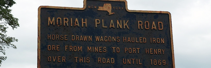
| MORIAH PLANK ROAD | On County Road Between Moriah And Port Henry | Horse Drawn Wagons Hauled Iron Ore From Mines To Port Henry Over This Road Until 1869 |
| MORIAH PLANK ROAD | On County Road Between Port Henry And Moriah | Horse Drawn Wagons Hauled Iron Ore From Mines To Port Henry Over This Road Until 1869 |
| MORIAH PLANK ROAD | On Co. Rd. Between Mineville And Moriah Center | Horse Drawn Wagons Hauled Iron Ore From Mines To Port Henry Over This Road Until 1869 |
| MORIAH PLANK ROAD | On Broad Street At Port Henry | Horse Drawn Wagons Hauled Iron Ore From Mines To Port Henry Over This Road Until 1869 |
| MORIAH PLANK ROAD | On County Road Between Moriah And Port Henry | Horse Drawn Wagons Hauled Iron Ore From Mines To Port Henry Over This Road Until 1869 |
| MORIAH PLANK ROAD | On Broad Street At Port Henry | Horse Drawn Wagons Hauled Iron Ore From Mines To Port Henry Over This Road Until 1869 |
| MORIAH PLANK ROAD | On County Road At Moriah | Horse Drawn Wagons Hauled Iron Ore From Mines To Port Henry Over This Road Until 1869 |
| MORIAH PLANK ROAD | On Co. Rd. Between Mineville And Moriah Center | Horse Drawn Wagons Hauled Iron Ore From Mines To Port Henry Over This Road Until 1869 |
| MORIAH PLANK ROAD | On County Road At Moriah | Horse Drawn Wagons Hauled Iron Ore From Mines To Port Henry Over This Road Until 1869 |
Historical Markers in Port Henry NY
| Marker Name | Location | Marker Text |
|---|---|---|
| SHORE LINE | On Nys 9N & Nys 22, Port Henry | Of Butterfield’s Bay. Boats Were Moored Along North Main Street Before Building Of Railroad Through Here |
| SITE OF | On Nys 9N & Nys 22, Port Henry | Porter’s And Lewis’s Mills Built 1766; Supplied Lumber For Fort Crown Point And Arnold’s Fleet. Entire Valley Dependent On Grist Mill |
| SITE OF | On Nys 9N & Nys 22, Port Henry | First Blast Furnace Erected In 1824 By Major James Dalliba; Converted Into Stove Works In 1827 |
| SITE OF | On Nys 9N & Nys 22 | Porter’s And Lewsis Mills Built 1766; Supplies Lumber For Fort Crown Point And Arnold’s Fleet. Entire Valley Dependent On Grist Mill |
| THIS BUILDING | On Broad Street At Port Henry | Erected In 1850 On South Main Street As Second Schoolhouse In Port Henry |
| TRAINING GROUND | On Nys 9N & Nys 22, Port Henry | Prior To 1850 Militia Of Southern Essex County Held June Training Here |